Other Raitt locations
Besides Rait Castle of the early de Rathe family in Nairn, there are various other places associated with the name Raitt. Whether any of them have anything to do with the early de Rathes family or whether, as has been surmized by others that the name Raitt originated in different localities as people came to take their surnames from a place, has still to be ascertained. And in fact the same name used in different counties may have been a cause for confusion amongst the early Victorian historians. Several of these similarly named places, and stories associated with them, are described below, including Rait (Perthshire), Raitts (Invernessshire), Raith (Ayrshire), Rath (Kincardineshire) and Rhaetia (Germany).
----------
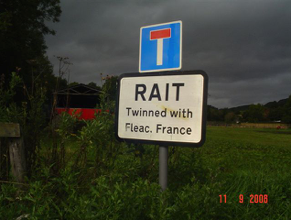
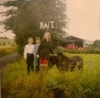
Rait
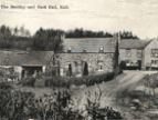
RAIT, in the Shire of Perth: an ancient Parish, now comprehended in the Parish of Killyspendy: The Church is in ruins. In this Village is the Half-way House, on the old road from Perth to Dundee.
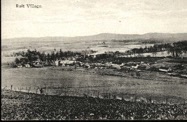
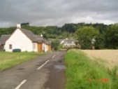
The old and relatively unspoiled village of Rait lies tucked-away in the Braes of the Carse at the mouth of the Glen of Rait where it opens out into the Carse of Gowrie, Perth and Kinross. There are a number of reed-thatched cottages and the remains of a pre-Reformation church, dating from the 1200s but abandoned when Rait united with Kilspindie around 1619. The village sign has changed over the years and the steading of Rait Farm is now used by antique traders.
According to the Rait Remembered page of the Rait Community Association website, Rait has a long and interesting history and for a very small village has witnessed many significant events and personalities over the centuries. Rait was formerly a coastal or esturial settlement – at one stage on the very frontier or boundary of Pictland. An early form of boat or canoe thought to be 2000 years old was found in the last century just along the “shore” at Flawcraig, complete with a rope tying it to a ring in the rock. Because of its strategic position, a defensive structure or fort (Rath)was built at Rait crossroads where it still stands. In the 17th century, cloth milling and weaving became the industry of Rait. There were said to be around 20-30 looms in the village at one time and examples of Rait linen were to be found in the best houses in the country. The last Laird of Rait died in 1937, thus ending over a thousand years of Lairdship in the village and Glen of Rait.
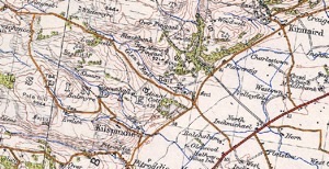
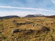
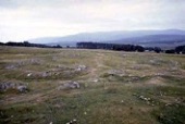
Raitts township remains
© Highland Folk Museum
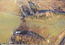
Aerial view of Raitts souterain
© Highland Council
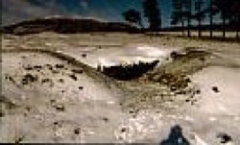
Raitts souterain
© Highland Council
Raitts chapel ruins at Lynchat
© Cushnie Enterprises
Reconstructed Raitts township
© Highland Folk Museum
Raitts township remains
© Highland Folk Museum
**********
And what has made this little excursion into Rhaetia suddenly become extremely more interesting is that in my latest YDNA test, I have the R1b-S28 marker which originates in the Alpine region!
In 1907 Mary Bradford Peaks presented her PhD thesis to the Latin Department of the University of Chicago. The title of her dissertation was The General Civil and Military Administration of Noricum and Raetia.
**********
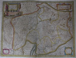
Serendipitously and fortuitously I recently came across an old map of Rhaetia in a Paris flea market! The map - apparently from an old atlas and about 80x50 cm - is by a well-known Dutch engraver, Ioannis Ionssonii, who made maps of the world and the French text on the back, which gave a potted history of Rhetie, showed it had been published in 1629 in Geneva. It says that the area took its name from Rhetus, chief of the Tuscans who were driven out by the Gauls who invaded Italy and took refuge in the mountains. I will get around to translating the text on the back and add it here. I wonder if the variation of Raitt/Rait spelled Rhet/Rhett takes on a more meaningful significance now?
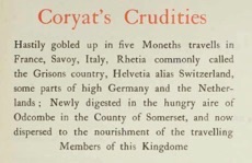
Some four hundred years ago Thomas Coryat (1577-1617) travelled extensively through Europe. His writings of his journeys, Coryat’s Crudities, were published in 1905 in two volumes and in volume two he devotes nearly ten pages to his visit to the area known as Raetia. His observations of the history of Rhetia, commonly called the Grisons Country, are described thus:
“The name of Rhetia commeth from Rhetus a certayne King of Tuscia, who being expelled out of his owne country by Bellovesus the Gaule about 587. yeares before the incarnation of Christ, at what time he conquered the Insubres, and built the City of Milan, came with many of his subjects into these valleys seated betwixt the Alpes, where they built Castels and fortifications for their defence. And after his time the country had his denomination from him as I have already said.
The country of Rhetia is at this day divided into two parts, the higher and the lower: all that Tract which beginneth from the farther edge of Switzerland, and includeth some part of Lombardy as farre as the lake of Como, (the inhabitants whereof are commonly called the
Grisons) is the higher Rhetia. The lower deriveth his beginning from the river Lycus, which divideth this from the higher, and extendeth it selfe as farre as the river Aenus, which boundeth Rhetia and Bavaria.
In sundry places of their country I observed divers Castles and Forts of great antiquity built upon high ground; rockes, and eminent hils. But now they are much ruinated, and of reparations : it is likely that these were built either by the followers of King Rhetus that inhabited this Country after he was ejected out of his Kingdome of Hetruria in Italy by Bellovesus the Gaule (as I have before said) or by the People of the country for meanes of defence against the armies of the Romans, that under the conduct of Julius Caesar and many other noble captaines of Rome, made themselves a way through this country by force of armes into Germany.”
According to Wikipedia (based on Encyclopaedia Brittanica) Raetia (or Rhaetia) was a province of the Roman Empire, bounded on the west by the country of the Helvetii, on the east by Noricum, on the north by Vindelicia and the river Danube, and on the south by Cisalpine Gaul. It comprised the districts occupied in modern times by eastern and central Switzerland (containing the Upper Rhine and Lake Constance), southern Bavaria and the Upper Swabia, Vorarlberg, the greater part of Tirol, and part of Lombardy. Later Vindelicia (south eastern Württemberg) and south western Bavaria formed part of Raetia.
Little is known of the origin or history of the Raetians, who appear in the records as one of the most powerful and warlike of the Alpine tribes. The Roman historian Livy (59 BC- 17 AD) stated that they were of Etruscan origin (a belief supported by others and apparently born out by DNA analysis). Pliny the Elder (23-79 AD) affirmed that they were a portion of that people who had settled in the plains of the river Po and were driven into the mountains by invading Gauls, when they assumed the name of "Raetians" from an eponymous leader named Raetus; a more probable derivation, however, is from Celtic rait (meaning mountain land). Even if their Etruscan origin be accepted, at the time when the land became known to the Romans, Celtic tribes were already in possession of the area and had amalgamated so completely with the original inhabitants that, generally speaking, the Raetians of later times may be regarded as a Celtic people, although non-Celtic tribes were settled among them.
The Raetians are first mentioned by the Greek historian Polybius (200-118 BC), though little is heard of them until after the end of the Republic in about 27 BC. However, they retained their independence until their subjugation in 15 BC by Tiberius and Drusus. At first Raetia formed a distinct province, but towards the end of the 1st century AD Vindelicia was added to it. The whole province was at first under a military prefect, then under a procurator; it had no standing army quartered in it but relied on its own native troops and militia for protection until the 2nd century AD.
During the reign of Marcus Aurelius, Raetia was governed by the commander of the Legio III Italica, which was based in Castra Regina (Regensburg) by 179 AD. During the last years of the Western Roman Empire, the land was in a desolate condition, but its occupation by the Ostrogoths in the time of Theodoric the Great, who placed it under a dux, to some extent revived its prosperity. Charlemagne (742-814) raised the district that was still governed under Frankish rule by a praeses in the 8th century to a county of Raetia (Raetien). Hunfrid, Margrave of Istria, was made count of Raetia in 807. His heirs were able to gather enough power that Burchard II (919-926) was able to make himself duke of Swabia, with the result that Raetia lost its separate identity and was absorbed into the duchy of Swabia at the beginning of the 10th century.
Raetia was the name of a canton of the Hevetic Republic from 1793-1803 when it was subsumed into the largest and easternmost canton of Switzerland known as Graubünden or Grisons. Today the canton shares international borders with Italy, Austria and Liechtenstein and is the only canton where the ancient Romansh dialects are still spoken. Most of the lands of the canton were once part of the Roman province called Raetia which was established in 15 BC.
----------
The charters relating to the granting of the land of Rath in Kincardineshire are given below. The translations, from the Latin, are taken from The Paradox of Medieval Scotland 1093-1286.
William, son of Bernard, has given, granted and by this his charter established to Arbroath Abbey 2 oxgangs of land called ‘Rath’ in the territory of Catterline (KCD), by its right bounds, with all its just pertinents and easements, as they were perambulated in the presence of Robert the steward, Roger of Balcathie, Edmund son of Gillemichael and Walter his son-in-law, Geoffrey, son-in-law of Simon the chaplain and Alan Homel, with liberty to build and have a mill in that land, and to have their multure free and quit, and similarly with their men, in pure and perpetual alms, free and quit from all army service and expedition, and other aids, gelds, works and wards, pleas and plaints, and other customs, services and secular exactions, and to have in common pasture in Catterline, 20 (work) animals and four horses. He and his heirs in perpetuity will acquit and respond for all services and accidents pertaining to that land. Dated circa 1198 and 25 February 1213.
William, son of Bernard, has given, granted and by this his charter established to Arbroath Abbey 2 oxgangs of land called ‘Rath’ in the territory of Catterline (KCD), by its right bounds, with all its just pertinents and easements, as they were perambulated in the presence of Philip de Maleville, sheriff of the Mearns, and in the presence of William chaplain of Catterline, Robert the steward, Utting of Balcathie, Alan Homel, Walter son of Osbert, Geoffrey, son-in-law of Simon the priest, Peter the marischal and Isaac, burgess of Arbroath. Dated circa 1198 and 25 February 1213
William, son of Bernard, has given, granted and by his present charter established to Arbroath Abbey 2 oxgangs called ‘Rath’ in Catterline (KCD), namely 7 acres adjoining ‘Rath’ on the north and 19 acres on the seacoast, called ‘Treiglas’, as perambulated in presence of Philip de Maleville, sheriff of the Mearns, William, chaplain of Catterline, Robert the steward, Utting of Balcathie, Alan Homel, Walter son of Osbert, Geoffrey son-in-law of Simon the priest, Peter Marshall, Isaac, burgess of Arbroath and many others, in pure and perpetual alms, free and quit from all army service and expedition, and other aids, gelds, works and wards, pleas and plaints, and other customs, services, from multure, and all secular exaction. He and his heirs in perpetuity will acquit and respond for all services and accidents pertaining to that land. Dated 17 February 1215 and 8 June 1222.
King Alexander II for Arbroath Abbey; has granted that donation which William, son of Bernard made of two oxgangs of land in territory of Catterline (KCD), that is, of seven acres beside abbey's land of 'Rath' and nineteen acres in _cultura_ of 'Treiglas', as charter of William, and confirmation of his son Bernard, bear witness. Dated 8 June, 1215 and 1222 at Forfar.
According to other sources, it also seems that Rath of Catterline was the subject of a grant in the time of Robert III. Since he ascended the throne in 1390, this may be simply a possible reconfirmation of the barony of Uras to Thomas Rait (or a successor) which embraced Catterline and the Rath.
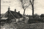
Rath
For good measure, we should perhaps also include Rath or Reath of Catterline in Kincardineshire - though whether it really refers to a place in the normal sense of the word or is using the term Rath in the meaning of homestead possession (see under Raitt Name) is unclear. The Rath or Reath of Catterline is a large steep-sided peninsula with no trace of defensive works - though, situated near the coast, it may have been a fort in earlier times and a stone axe found in the Rath Field is now in the National Museum in Edinburgh.
The following is summarized from the Creel Inn, Catterline website.
The church of Caterlyn with it's lands, teinds and offerings was granted to Arbroath Abbey by it's founder King William I at, or soon after its foundation in 1178. Around 1206 the apparent owner of the lands of Katerlyn gave two oxgangs of land called Rath in the estate of Catterline. with the use of the mill of Katerlyn to the Abbey. Around 1222-40, William, son of Bernard confirmed the earlier gift and also granted 19 acres by the sea called Tregles with its rights and pertinents. Both gifts were witnessed by the donor's son and heir Bernard (son of William son of Bernard) "within the farm of Tregles".
Rath was obviously the Reath of Catterline, the high ground south of the village between the Catterline burn [at Bellefield] and the sea. In 1371 King Robert III granted to Thomas Rait the barony of Uras with its fishing's (Crawton), also Cloak and Hilton and other lands to the north and Katerlyn with rights over the haven, of old owing and customary but with no mention of fishing's or a fishertown. [Nearby is Dunnottar with its castle which Thomas Rait also possessed.] In 1483 Arbroath Abbey leased their lands of the town of Katerling with the mill……. In 1526 the Abbey's lands and the mill were leased……. The next lease in 1542 …… The lands belonging to the Abbey were not necessarily in a compact block, they included the Rath or Reath as described above……
The above text is not quite correct I don’t think, because Robert III did not come to the throne until 1390; Robert II ascended in 1371 and in 1383 confirmed the grant by David II of the lands of Uras, Catterline and more to Thomas Rait who was already in possession of the lands and castle of Dunnottar since 1341 (see under Raitt Residences - Dunnottar).
----------
Mention must also be made of the Battle of Raith in the year 596, fought between the Angles and an alliance of Scots, Picts and Britons led by King Áedán mac Gabráin of Dál Riata, which is believed to have taken place a mile or so to the west of Kirkcaldy in Fifeshire. A description of the Raith estate and mansion which was subsequently built there a thousand years later is provided under Raitt Residences. Sir John Melville of Raith payed homage to Edward I in 1296.
Raith
Raith, near Monkton in Ayrshire is considered a habitational name. It is noted that possibly the first, permanent settlement of the Gemmills (dislocated refugees from England) in Scotland was in the upland portion of Ayrshire known as Fenwick on the old lands of Raith in the year 1264.
We know that the Ragman Roll list of the attendance at Edward I's 1297 Parliament included a Roger de Rathe from the county of Ayr. He may very well have been the possessor of these old lands of Raith - but did he give or take his name from the place? And was he related to Gervaise and Andrew de Rathe in Nairn? Hugh de Rathe was appointed coroner of the sheriffdom of Ayr by Sir John Lindsay (Great Chamberlain of Scotland) and had a Crown charter of confirmation in the second year of Robert II (i.e 1371-1372). However, he may or may not have originated in Ayrshire.
But in Ayrshire I have also found Alexander of Rath in 1338, Alexander Raith in 1431, references to the lands of Rath (1437), Raith (1542) and Rayth (1589) and other individuals named Raith and Rayth in Ayr in the 1580s (see more under Raitt Name.)
The lands appear to be in the Ayrshire conjoint parish of Monkton and Prestwick, though they could just lie in the parish of Torbolton. However, there is no mention of Raith in the either the Old or the New Statistical Account of Scotland for either parish, though they do give much information on the ancient history (including Roman, Danish (Vikings) and Old King Cole of the nursery rhyme) of the region.
In the graveyard of the old Prestwick parish church, St Nicholas, have been found the graves of Knights Templars - it is tempting to think they might have been associated with Raith and Roger de Rathe.
No history or description of Raitts would be complete without the entries from the Statistical Accounts of Scotland. In the Statistical Account of Scotland, v13, published in 1794, for the Parish of Alvie, under the heading Curiosities, it simply notes:
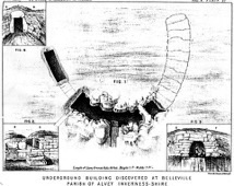
“The only curiosity is an artificial cave upon the estate of Raits, 2 miles from Pitmain, and within few yards of the high-road; it is 60 feet long, 9 broad, and 7 high, the sides built with stones •, it is covered with large flags or flat stones, over which has been built an house; the entry to the cave, is said to have been in the centre of the house, by raising a flag. There is a number of tumuli on each side the high-road, nearly opposite to the manse; curiosity prompted some of the neighbouring gentlemen to open the most conspicuous one, where were found the bones of a human body entire, and in order, with two large hart-horns across.”
However, the entry for the parish of Alvie in the New Statistical Account of Scotland, v14 Inverness – Ross & Cromarty and dated April 1835 provides much more information and was possibly at least one of the sources for the later Victorian literary efforts quoted above.
“The mountains of this parish are composed solely of gneiss, which is intersected with veins of granite and red porphyry, of which there are fine specimens in the Burn of Raitts at Belleville. Limestone is quarried at Dunachton, a part of Mackintosh's property, and veins of lead occur in the gneiss in the Burn of Raitts, and at Tyncaim, both on the property of Belleville.
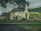
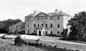
Belleville, a district of this parish, has been rendered classical ground by the residence of James Macpherson, Esq. the collector and translator of Ossian's Poems. By his literary works, Mr Macpherson raised himself from the humble situation of a parochial schoolmaster to a distinguished reputation among men of letters, and realised an ample fortune, by which he was enabled to purchase a good deal of landed property in his native country. His remains were carried from Belleville, where he died, to Westminster Abbey, and deposited, agreeably to his own particular instruction, in Poet's Corner. Belleville is now the residence of Sir David Brewster, whose scientific acquirements entitle him to notice here, and to whom the writer of this account is indebted for some important information. It is unnecessary to add, that Sir David is a valuable acquisition to the society of this remote but beautiful Highland glen, where he enjoys ease with dignity.
Concerning the cave at Raitts near Belleville, slightly noticed in the former Statistical Account, several curious facts have been handed down by tradition, which here deserve to be recorded. This cave, of which the excavation when entire amounted to 145 solid yards, was artificially built round with dry stones, and covered on the top with large gray flags, by a desperate band of depredators, nine in number, commonly called Clannmhicgillenaoidh. It is not certain to what particular clan these depredators belonged. Instigated by implacable revenge against the Macphersons, on account of some deadly feud, they secretly dug the cave, which is called, after their name, Uaigh Clannmliicgillenaoidh, as a place of concealment, from which they occasionally sallied forth in the night time to steal and to slaughter the cattle of the Macphersons, wherever they could be found. Over the cave was erected a turf cottage or dwelling-house, such as the people of the country inhabited at the time, the inmates of which enjoyed the confidence of Clannmhicgillenaoidh, were the depositaries of their secrets, and participated along with them in the spoils of the Macphersons. The Macphersons finding the number of their cattle daily diminishing, made a strict search after them, but for a long time without effect. At length appearances were noticed about the hut erected over the cave, which excited a strong suspicion that the lurking place of those depredators could not be very distant from that hut. This suspicion was increased by the inhospitable churlishness of the landlord, who, contrary to the custom of the times, would permit no stranger to lodge for a single night in his house. Accordingly the Macphersons sent one of their number as a spy in the garb of a beggar, to solicit a night's lodging in the suspected hut; and feigning illness from a fit of the gravel, the beggar was allowed to remain in a barn or outhouse for the night. The beggar being thus disposed of, the most active preparations commenced within the house for a sumptuous entertainment; and the feast being prepared, a large flag was raised in the centre of the house, on which Clannmhicgillenaoidh came out, feasted on the Macpherson's choicest beef, along with the inmates of the house, and then spent the remainder of the night in search of a fresh supply. The beggar observed all that passed through an aperture on the side of the hut, and returned to report what he had seen. In consequence of the discovery thus made, the Macphersons collected a strong party on the following night, seized and massacred the whole band of Clannmhicgillenaoidh, in the cave, demolished the hut erected over it, and thus put an end to these freebooters, and to all their depredations. The pretended beggar by whom Clannmhicgillenaoidh were betrayed was called Ian Mac Eoghaiwn, or John Macewan, and the tribe of the Macphersons descended from him are distinguished by the appellation of Sliochd Ian Mhiceoghainn, that is John Macewan's descendants. It is said that all this tribe have ever since been peculiarly liable, at some period of life, to be more or less afflicted with gravel.
Modern Buildings.—There are only two buildings in the parish entitled to particular notice. The first of these is the house of Belleville, built by the translator of Ossian, after a design by the celebrated architect, Robert Adam, Esq. It stands on a beautiful eminence, conspicuous from the public road, sheltered on the north by a plantation of Scotch fir and larch, now grown to a considerable size, and by the beautiful rock of Craigbuie, covered with natural birch, among which are some trees of unusual magnitude. The lawn in front of the house is adorned with upwards of 100 large trees of hard wood, and a fine row of elms along the Old Military Road, planted by Brigadier Mackintosh in 1715. The other is the house of Kinrara, built by the late Duchess of Gordon, in the form of a cottage, on a very sequestered and romantic spot,
There is a private school taught at Raitts, a remote district of the parish, only in the winter season, and supported by the parents of the children attending; a situation in which a permanent school is much required.
----------
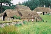
“Raitts today is one of those numberless Highland localities where everyone who ever mattered is dead and gone.” But it still lives on, however, in the open air Highland Folk Museum at Newtonmore which is based upon the settlement of Easter Raitts and takes you back to the times of the Jacobite Risings.
This was not the only connection Raite had with the Church of Moray. In a charter by William the Lion to his beloved Richard - in which he granted him, among other subjects, the Church of Auldearn with the Chapel of Nairn - the Chapel of Raite is included, and it is mentioned in a subsequent charter of William's, along with the Chapel of Moyness. King Alexander II. confirmed to Andrew, Bishop of Moray, in 1226, his right to various subjects in Rothiemurchus, Darnaway, Logic, and other places on the Findhorn, and to thirty acres " in Whitefield at Rathe." A doubt may exist whether in this instance the chapel of Raite in Badenoch may not be intended, but in the canonical statute a few years later assigning the benefices, it is stated the Dean of Moray is to have the lands and Church of Auldearn and Nairn, excepting the half-davach of land at Raite which belongs to the Episcopate of Moray as a table pertinent. A davach was equal to what could be ploughed by a pair of oxen, and half-adavach of land appears to have been the extent usually assigned to the brethren of the old Celtic Church. It is incidentally mentioned in a Kilravock charter that the Chapel of Raite was called the Hermit's Chapel, though, re-dedicated to the Virgin.
In fact it may be that the chapel is even older. An entry in the Royal Commission on the Ancient and Historical Monuments of Scotland database gives the site of Raitts Chapel as Chapelpark Farm, Lynchat and notes that the chapel, dedicated to St Moluog (who founded the monastery at Lismore and died in AD 592), is mentioned in documents from the 13th and to 14th centuries and appears to be one of a suite of 9th and 10th century chapels in Badenoch. The chapel, for instance, is mentioned in the Registrum Episcopatus Moraviensis, ed. Cosmo Innes, Edinburgh, 1837 with a date of 1451. Though incidental mention is made in 1343 of the hermit of the chapel of St Mary of Rait.
In Macpherson’s Glimpses there is an astonishing paragraph which further confuses the issue! “With the old Castle of Raitts, which stood on or near the site of the present mansion-house of Belleville, the following incident is said to have been associated:--
"In a great battle between the Comyn and Macintosh, the former was defeated, and, being either unable or unwilling to renew the war, he proposed a peace, which was accepted. To celebrate it, the Comyns invited the Macintoshes to a feast in his castle -- the design of these hospitable and honourable personages being to seat a guest alternately among themselves as a distinguished mark of friendship, and, at a concerted signal, to murder them, each stabbing his neighbour! The signal was the introduction of a bulls head; but their purpose having been revealed by a Comyn, the tables were turned on their hosts, and thus all the Comyns were killed. Such were the horrible deeds of other days, perpetrated under the guise of friendship and hospitality!”
Did this incident really take place at the old castle of Raitts in Badenoch or at the old castle of Rait in Nairn? I have tried to resolve the issue in a blog entry on the Castle of Rait and under Rait lands there are references to the early history of Raitts/Raites/Raite near Kingussie in Badenoch.
----------
Another famous son was Lachlan McIntosh who was born near Raitts in Badenoch on 17 March 1725, and emigrated to America when his father, John Mohr McIntosh, moved his family to Georgia in 1736 and with a group of other Scottish emigrants founded the ill-fated settlement of Darien. (Dundee merchant, Alexander Rait was a subscriber to the Darien Scheme in 1696 and contributed £100.) Lachlan wanted to return to Scotland to join the Jacobite rebellion, but was persuaded to remain in America where he became a military and political leader during the American Revolution.
----------
Easter Raitts was not the only part of the settlement to have a mention. From the History of Nairnshire by George Bain and published by the Telegraph Office in 1893 we discover that John Hay of Tullybothil founded a chapel at Kincraggie out of his lands of Lochloy, the house of Wester Raite, and certain lands and pasturage. The charter is dated at Raite in 1374. There is no "Kincraggie" in Nairnshire, but Craggie was a well-known possession which lay adjacent to and was generally included in the estates of Knockoudie and Park which belonged to the Hays of Lochloy and Tullybothil from a very early date. The name still occurs in the Valuation Roll, though these places have been united into one farm. The site of the chapel was in all probability at the head or high ground where the streamlet known as the Craggie Burn takes its rise. The chapel was dedicated to St. Mary, and the priest's duty was to say masses for the soul of Sir John himself, and the souls of his ancestors and successors. Sir John Hay was Sheriff of Inverness at the time he made this grant of an annuity of four pounds usual money out of the lands of Lochloy, the one half to be paid at the Feast of Pentecost and the other at Martinmas, with two acres of land and the mansion in the town of Wester Rait, with pasture in the same town for twelve cows and a bull, sixty sheep, and liberty of pasturing horses on the common pasturage - no doubt the common on the Hill of the Ord adjacent.
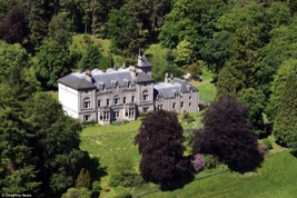
According to Place Names Highlands and Islands of Scotland by Alex MacBain and published in 1922 by Eneas MacKay, the place became known later as Belleville. “Belleville is, in its English form, of French origin, and means " beautiful town." The old name in documents and in maps was Raitts, and in the 1776 Roads' Map this name is placed exactly where Belleville would now be written. Gaelic people call it Bail' a' Bhile, "the town of the brae-top," an exact description of the situation. Mrs Grant of Laggan (in 1796) says that Bellavill is the true Highland name of the place," not Belleville; and it has been maintained by old people that the place was called Bail' a' Bhile before "Ossian" Macpherson ever bought it or lived there. Whether the name is adopted from Gaelic to suit a French idea, or vice versa, is a matter of some doubt, though we are inclined to believe that James Macpherson was the first to call old Raitts by such a name”. James Macpherson was the most famous - or rather the most infamous of Badenoch’s sons.
In Shaw’s History of the Province of Moray (mentioned above), we learn a little more about Belleville and its association with Rait. “Belleville, which gives its name to a district in this parish (Alvie), was the property of James MacPherson, the author or translator of Ossian's poems, who died here on the 17th Feb. 1796, aged 58; but was buried, at his own desire, in Westminster Abbey. The lands of Belleville were formerly the possession of Macintosh of Borlum, the leader of a gang of robbers. Belleville House occupies the site of Raits Castle, the chief ancient stronghold of the Comyns. It is an elegant mansion, after a design by the celebrated Adam, situated on a fine eminence sheltered on the north by an extensive plantation of Scottish fir and larch, and by the rock of Craigbuie covered with natural birch. By his literary labours, MacPherson raised himself from the humble profession of Parish Schoolmaster at Ruthven, where he was born, to a prominent position among the literary men of his time, and realized an ample fortune which enabled him to purchase the estate of Belleville. Among the many legacies and annuities which he left, his will directed that £300 should be expended in erecting a monument to his memory in some conspicuous situation at Belleville, which was done. Within a clump of larches, about half a mile south west of the mansion, and near the public road, there is a beautiful marble obelisk on which is fixed a medallion of MacPherson. On his death, Belleville passed into the possession of his son, who died in 1833, when it fell to his elder sister, the first spouse of Sir David Brewster, who lived here for some time.
And MacPherson writing in Glimpses of Church and Social Life in the Highlands in Olden Times (mentioned above) has this to say:
Failing in healthy and seeking rest from the din and turmoil of political and public life in the great metropolis, [James] Macpherson retired at length to Belleville, a beautiful estate which he had purchased in the parish of Alvie, where, from a design by the 'Adelphi Adams' -- the famous architect of the Edinburgh University buildings and St George's Church, Edinburgh -- he built a handsome residence, situated within two or three miles of the spot where he had been born, and commanding a magnificent view of the Grampians and the valley of the Spey. Writing about half a century ago [1840s]:--
“This mansion," says Dr. Carruthers,"was built by the poet when fame and fortune had crowned him; here he died, and here his eldest daughter, Miss Macpherson; still resides. The situation of the house is beautiful; commanding a full view of the valley and river, and bounded in front by two ridges of hills, those of Invereshie, and the grey mountainous ridge of the Grampians. The property was purchased about the year 1790 by the poet from the family of Mackintosh of Borlum -- a small Highland laird who disgraced his clan and descent by highway robbery, committed not in the old legitimate piratical way of levying blackmail, but by attacking travelers. His last exploit was the robbery of a carriage, for which his associates were hanged; but the prime offender contrived to escape to America. A cave is shown in the rock where the bandit group used to watch the approach of travelers, and rush down on their unsuspecting prey.
The hillside is now covered with trees, and near the mansion are some fine old elms, planted by Brigadier-General Mackintosh, who was so intimately connected with the public insurrection of 1715. The Brigadier was a rough soldier, trained to war in France, and when confined in prison for his share of the rebellion, he had the taste to order a row of trees to be planted along the roadside, below his residence The poet changed the name of the estate from Raitts to Belleville, and pulling down the old Highland domicile, erected the present stately structure.”
The home of James Macpherson was named Belleville initially but pronounced 'Balville'. Over time it became 'Balavil' which continues to this day. In fact, in 2013 the house was up for sale and there is an interesting little video clip about the history of the house.
The following quote is taken from the Antiquarian Notes mentioned above: “In fact it seems that every place James Macpherson acquired was cleared, and he also had a craze for changing and obliterating the old names. The first attempt....was stopped by the Duke of Gordon. Another attempt of Mac Ossian’s was more successful - changing Raitts into Belleville. This last seems of late undergoing a further change into Balavil, perhaps to emerge in time, even in English, into Palaville. Upon this point it may be noticed that Mac Ossian, in making an entail and calling four of his numerous bastards in the first instance to the succession, declares an irritancy if any of the heirs use any other designation than that of "Macpherson of Belleville."”
A longer version of the story about the old Cave of Raitts in Badenoch is told in Alexander Macpherson’s Glimpses of Church and Social Life in the Highlands in Olden Times. The distinguished philosopher, Sir David Brewster (the son-in-law of the translator of Ossian's poems), while resident at Belleville) in 1835, made a careful exploration of this remarkable cave, and in a communication to the Society of Antiquaries in 1863 (when he was Principal of the University of Edinburgh) he thus describes it: --
"This cave is situated on the brow of a rising ground in the village of Raitts, on the estate of Belleville. It is about two miles from Kingussie, and about half a mile to the north of the great road from Perth to Inverness. In 1835, when it was first pointed out to me, it was filled with stones and rubbish taken from the neighbouring grounds. Upon removing the rubbish I was surprised to find a long subterraneous building, with its sides faced with stones, and roofed in by gradually contracting the side walls and joining them with very large flattish stones. The form of the cave was that of a horse-shoe. Its convex side was turned to the south, and the entrance to it was at the middle of this side by means of two stone steps, and a passage of some length. The part of the cave to the left hand was a separate apartment with a door. A lock of an unusual form, almost destroyed by rust, was found among the rubbish. The formation of the roof by the gradual contraction of the side walls is shown in the drawing. There is no tradition among the people respecting the history of this cave, and, so far as I know, it had not been previously noticed."
In stating that there was no tradition among the people at the time regarding the cave, Sir David must have been misinformed. "Old Biallid's" account of it appears to have been written prior to 1835, and in a quaint diary in my possession, which belonged to the Rev. William Blair, who was minister of Kingussie from 1724 to 1786, there is the following reference to the cave in a description of a journey from Edinburgh to Inverness:
"We visited the Cave of Clan Ichilnew, which is not far from the side of the highroad. We descended into it, and found the greater part of it fallen in, and could only perceive a dark hole through which we could not see the farther end. The stones that support the roof are of an enormous size -- in length about twelve feet. The accounts given of this subterranean mansion are various. The people there give this account: That in primitive ages, when anarchy prevailed throughout the island, the country was infested with men of a gigantic stature who had often made fruitless attempts to conquer the island. Being repulsed at a time when they made their last and most formidable attack, such as were not either killed in the flight or escaped by sea fled into the mountains, and being closely pursued by the enemy until night stopt the pursuit, they advanced so far as the Spay, and in a night's time finished the said cave, and lived there for some time, till, by the continual searches of the conquerors, they were at last discovered and every man killed."
Here is "Old Biallid's" account of the cave, under the title of The Macnivens' Cave:-- "This artificial cave is on the farm of Raitts in Badenoch, and is still nearly entire. Its history is as follows: When the Clan Chattan lost their patrimony in Lochaber by the marriage of the heiress of the clan to the son of the Thane of Fife, the Macphersons, who opposed the pretensions of the husband to the chieftainship, were gradually expelled their possessions, and found an asylum in Badenoch, then occupied by the Macnivens, as vassals of Comyn Earl of Badenoch. The emigration from Lochaber continued for several years, but it was not until the restoration of Robert Bruce and the downfall of the Comyns that the Chief of the Macphersons made a purchase of the lands of Cluny, &c., and came to reside there. In consequence of that event the Macnivens became alarmed, and took every opportunity of insulting Cluny, who was not then sufficiently strong to resent or punish their conduct.
An occurrence, however, happened which brought matters to a crisis. The Chief of the Macnivens, who resided at Breakachy, and was Cluny's next neighbour, poinded Cluny's cattle, and as there was much bad blood between the parties, it was considered dangerous that the men should come in contact. It was therefore resolved to send Cluny's daughter to relieve the cattle; but instead of paying that deference due to the rank and sex of the young lady, she was treated in the most brutal manner: her petticoats were cut off, and in that state she was sent home to her family.
The cattle were also sent home, but the bull's tongue was cut out, which in these times was considered as a direct challenge. Such a gross outrage could not but inflame the Macphersons to the highest pitch, and as they were not equal to their adversaries in point of numbers, one called Allaster Caint collected a band of one hundred resolute men, with whom he set out at night, and before the sun rose next morning there was not a living male Macniven in the lordship of Badenoch except eighteen that contrived to conceal themselves in the woods of Raitts.
These men managed to elude the vengeance of Allaster Caint until they constructed a cave under the floor of their dwelling-house, and which they did with such skill and secrecy that they were enabled to keep possession of the place for several years. They slept securely in the cave at night, and in the daytime they kept so good a look-out that their enemies could never get them into their power until the cave was discovered by the following stratagem: Allaster Caint concealed himself under pretence of sickness until his beard grew to a great length. He then disguised himself in the habit of a beggar, and came in that character to the house of the Macnivens late of an evening, when he was kindly treated by the women, but refused lodgings for the night. He begged hard to be allowed to remain, and when they attempted to remove him by force, he pretended to be afflicted with gravel, and uttered such piercing shrieks that they had pity on him, and allowed him to lie at the fireside, where, after a great deal of mock moaning, he pretended to fall sound asleep, and by this artifice discovered the cave; for, believing him to be really asleep, the door was opened to give the men their supper. He left the house early in the morning, and in a few days thereafter he returned with a strong party, and beheaded every one of the unfortunate Macnivens upon the stump of a tree before the door. The most singular circumstance connected with this tragic affair is, that every one of the descendants of Allaster Caint to this very day has been afflicted with gravel."
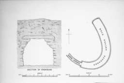
The cave was well known to the old natives of Badenoch under the name of An Uaimh MhÚir -- i.e., The Great Cave. It is now generally known in the district as The Robbers' Cave, but it is evidently of a much older date than common tradition assigns to it. I am indebted to Mr David MacGibbon, architect, Edinburgh, one of the accomplished authors of The Castellated Architecture of Scotland, for the following particulars and for the plan of the cave. It is curved as shown on the plan; The side walls are built with large stones, those towards the top being pushed inwards so as to diminish the space, and the top covered in with a long stone, as shown in section. The entrance is very narrow, and has apparently sloped down from the surface to the doorway, which is composed of massive stones, the jambs of which incline inwards towards the top. This doorway has been defended either by a stone or wooden door strengthened by a strong sliding bar on the inside, the holes or slots for which are still visible. The portion of the roof next the entrance has fallen in, but the greater part of the stone roof still exists.
Another lengthy version of the tale that mentions the woods of Raites in addition is to be found in the Macpherson’s Invereshie Book.
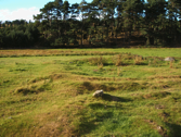
A possible structure, pottery and a stone tool (thought to be a stone Ard point, a rock worked into a point for use as part of a plough) dating from the Iron Age have been found during work in late 2017 to build a new stretch of dual carriageway on the A9 road between Crubenmore and Kincraig. It is believed the finds could be associated with the nearby souterrain known as Raitt's Cave.
Raitts Cave it is the subject of several folk tales. Indeed, in volume 1 of the History of the Province of Moray by Lachlan Shaw and published in 1882, it is noted that “there is a curious artificial Cave at Raits, near Belleville, the dimensions of which, when entire, was 145 solid yards, artificially built round with dry stones, and covered on the top with large grey flags. This cave was constructed by, and made the resort of a band of robbers, nine in number, who were designated by the unpronounceable name of Clannrishicgillenaoidh, Over the cave was erected a turf cottage, the inmates of which participated with the robbers in their spoils, chiefly carried on in revenge upon the MacPhersons, whose suspicions got excited. They, accordingly, sent one of their tribe, attired as a beggar-man, to seek quarters for the night in this dubious hut. Pretending to suffer from the gravel, the pauper was allowed to stay in another rude domicile hard by; who narrowly watched proceedings. By-and-bye a large flag-stone was raised within the hut, whence issued the entire band prepared for a sumptuous feast on the MacPhersons' mutton. By this stratagem the marauders were found out; and next night the MacPhersons massacred the whole.”
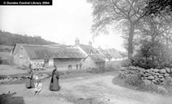
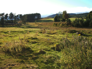
Raitts
Raitts - the English plural being used to denote that there were three Raitts - Easter, Middle, and Wester. In 1603 the place was called Reatt, and Blaeu has Rait. The Gaelic is Rat, and this, which is the usual form in Highland place-names, is a strengthened form of the older rath or raith of Old Irish, which meant a residence surrounded by an earthern rampart. It, in fact, meant the old farm house as it had to be built for protective purposes.
Another definition or explanation is provided in the earlier book Glimpses of Church and Social Life in the Highlands in Olden Times by Alexander Macpherson and published in 1893.
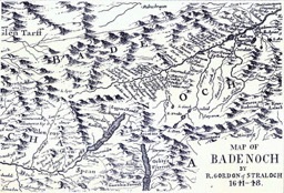
RAITTS (Gaelic, Rýt, signifying a stone circle. The term Rýt -- in the older form RÚth -- was applied to places set apart for Druidical rites, or for the purposes of religious worship. Hence glebe lands are to this day termed, in Gaelic, Rýth mhinisteir -- i.e., the minister's land or portion). In Scotland the Stone Circle was also used at times as a Law Court, and in the Chartulary of Moray a regality court was held by Alexander Stewart, Lord of Badenoch and son of King Robert II at the Standing Stones of Raitts, stating "apud le standard stanes de la Rath de Kinguey."
The village of Raitts, then comprising Upper Raitts, Easter Raitts and Wester Raitts, lying in the district of Badenoch near Kingussie, was cleared around 1800 by its then landlord, James Macpherson. A long list of the names of some of the residents evicted carried out by James Macpherson, the younger, in 1801, 1802, and 1806 is to be found in Antiquarian Notes: Historical, Genealogical, and Social (Second Series): Inverness-Shire Parish by Parish by Charles Fraser-Mackintosh, published in 1897. The foundations of several houses and other buildings and as well as the outline of a sunken roadway, can still be seen today in the grass. Although the visible remains date to the 18th and early 19th centuries, the site had already been occupied in medieval times.
Rait burn runs through the area and nearby is a prehistoric souterain with much of the roof still standing. Ongoing excavations have turned up numerous pottery and other artifacts. Known as the Cave of Raitts or An Uaimh Mhor, it is found in the village of Raitts on the Belleville estate. Described as an 'erd' or earth house, the cave is built with enormous stones and is in the shape of a horseshoe. The cave was probably used as a cool store for surplus food (and such souterains were usually near wealthier households) but local tradition has it that the cave was built by members of the MacNiven clan to hide from the MacPhersons who were pursuing them. This has led to the cave being known locally as MacGillenaoimh's Cave or MacNiven's cave.
In an earlier book by John Wilson and published in 1860 entitled The Presbytery of Perth (which includes memoirs of the members, ministers of the several parishes within the bounds, from the Reformation to the present time) we find the entry:
KILSPINDIE AND RAIT.
KYNSPINEDIN-KYLSPYNDY— KILSPINDIE-RATE— RAIT.
Prior to the Reformation these formed two separate parishes, but have been united ever since. "Malcolm Abbe de Knyspinedin" is mentioned in the Book of Scoon as witness to a charter granted in the time of Alexander II; and Henry Cramby vicar of the church of "Kylspyndy," is witness to another charter of date 4th November, 1491. The Parish Church of Kilspinedy was one of the churches of the Abbey of Scone. See Bull of Pope Benedict in the reign of Robert III. "John de Rate granted certain privilegs to the Abbot of Scone by a charter dated 1332." Rate declared to be a chapel of the Abbey of Scone in a charter of the time of William the Lion (1165-1214.)
In 1563, Alexander Jarden was styled as minister of Kilspindie, Inchture, and Rait; while in 1574, Mr Alexander Dunmure was minister of Errol, Rait, and Kilspindie, having under him Neil Ramsay, Reidare (reader) at Rait.
----------
In the Statistical Account of Scotland for Kilspindie (vol 4, dated 1792) it notes that there were originally two parishes, Rait and Kilspindie, and the walls of the church of Rait are still standing, though it is not known at what time the two parishes were united. It goes on the say that “there is a hill of gravel, a little to the S.E. of the village of Rait, upon the top of which, there are evident marks of some old fort or entrenchment. It is much impaired, and on one side wholly ruined, by the encroachment of a small stream that runs at the bottom of it. The common people have no tradition with regard to it.”
In the New Statistical Account of Scotland for the parish of Kilspindie in 1843, it is noted that there were originally two parishes, Rait and Kilspindie, but it has not been ascertained when their union took place but it must have been prior to 1634. The walls of the church of Rait are still standing. In the parish of Kilspindie are three small villages: Rait, containing 47 families, Kilspindie, 18 and Pitrodie, 16. In each of these a few hands are employed in the manufacture of linen fabrics for the Dundee market. There is a private school in the village of Rait.
----------
One other interesting fact which may attest to the antiquity of Rait is that according to the Chronicles of the Picts and Scots, in several places, it is noted that Donald mac Alpin (brother of Kenneth mac Alpin) who, as Donald I, was King of the Picts from 858-862, died at Rait near Scone in 862 (though like other Pictish and Scottish kings he was buried on Iona.) A later King, Constantine III was also killed there in 997. The place is given in some sources as Rathinveramon - fort at the mouth of the river Almond. The Almond flows nearby Scone on one side, while Rait burn flows nearby on the other and the ancient fort is located in this area.
----------
There are a number of early charters referring to Rait in Perthshire. The translations below, from the Latin, are taken from The Paradox of Medieval Scotland 1093-1286.
Recognition was made of the bounds between the land of the lord king of “Herbertoli” (now Airntully, Kinclaven ph., PER), and the land of Inchturfin, which belongs to the abbot and convent of Dunfermline, by the following: Robert de Haye, William of Blair, John of Luncarty, William son of Roger of Clunie, Gillecrist father of the said Ewen, Ewen Makinkerd, Warin of Auchtergaven, Adam of Murthly, William of Pitkierie, Matthew mair of Glasclune, the suitor of “Lochnidi” and with him, Furni and Bruide, the suitor of “Culmedi” with Kelan and Gille Mo-Luóc, the suitor of Meikleour with Ralph and Robert, the suitor of Kendeloch with Martin and Gillemuire MacAlpin, the suitor of Auchtergaven, with Duncan Small and Colin Macindeor, Gilbert son of the suitor Inchtuthil with Roger son of Hugh and Gilbert son of Colin, the suitor of Balliefurth with Hugh and Robert of that place, the suitor of Caputh with Gillemuire and Maceroht, Robert of Caputh, the suitor of Murthly with William Callander, and the sergeand of Murthly, the suitor of Luncarty, the suitor of Dalmarnock, Cristin, suitor of Strathord with Colin MegDubgaill and Macbeth Macbanhyl, the suitor of Rait with Macbeth and Gillebrigte. Dated after 1220 and before 1250.
Robert, earl of Strathearn, has given, granted, and established by his charter, to Inchaffray Abbey in pure and perpetual alms the land called Raith (PER - in the parish of Trinity Gask), namely, a quarter part of all ‘Dunphalin’ (PER), with all it just pertinents, free and quit of all service and secular exaction, except the aid of the lord king when the lord king imposes a common aid on the whole kingdom. The earl will perform the forinsec service of the lord king pertaining to the said land for them. Dated 1223 and 1225.
King Alexander II for Scone Abbey; has handed over at perpetual ferme his demesnes at Rait and Kinfauns, in Gowrie (PER), with neyfs of same land, for an annual rent of 40 chalders of good quality wheat and 60 chalders of first-grade malt, payable at abbey's granges of Rait and Kinfauns, and by providing forinsec service due from these lands, saving to canons second teinds collated to them in perpetual alms by king and his predecessors.
Dated 30 June 1233 and 1241.
Alexander, king of Scots, has given, granted, and by this charter established, to Master Ralph of Dundee, his clerk, that half ploughgate in the territory of Rath (Rait or Rath in Gowrie) which Robert Wishart, clerk, son of the late Utring called “Castball” held from the king and, on account of the lack of service which is owed to the king, Robert returned (reddidit) this by rod and staff to the king on Wednesday after the feast of the translation of St Thomas the martyr (i.e. 7 July 1284), at Dundee, and quitclaimed and resigned all right which he had or could have in the said land for himself and his heirs. To be held by Master Ralph of the king in feu and heritage, rendering one pound of pepper yearly at Pentecost and making forinsec service which pertains to it. Dated 11 July 1284 (36th year of king’s reign) at Dundee.
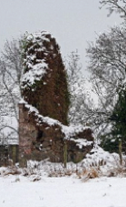
The medieval period from approximately the 12th century onwards sees Rait continue to flourish and from the thirteenth century a Norman influence is discernible. The Normans, who invaded England in 1066 and indeed came up to the banks of the Tay at Abernethy, under William the Conqueror, to “treat with the Scots” had a huge influence on Scotland. Anyone who was anyone was at great pains to Normanize themselves. Thus the proprietors of Rait at the time styled themselves “de Rait” and it is possible that Gasconhall there in some ways owes its name to French influence. John de Rait seems to have been a fairly influential person at Court in the 13th and early 14th centuries but either he or his son of the same name lost his lands to the crown in the 1360s, resulting in the Rait family moving to Hallgreen Castle in Angus where they remained for the next 400 years. [This is an interesting statement and one wonders at the truth of it, especially as Hallgreen Castle was in The Mearns or Kincardineshire rather than Angus and was apparently not built until 1376 - did the de Rathes of Nairn flee to Hallgreen because other de Raits were already there? Or is there some confusion as to dates and places? In fact, in volume 2 of Rotuli scaccarii regnum Scotorum (Exchequer Rolls of Scotland), published in 1878, it is stated that Queen Margaret was endowed by her husband King David II with many lands and possessions as part of her dowry in 1364. Lands in Perthshire conveyed to her included the thanage of Rate which in 1367 was making payments to her, whereas in 1361 payments of fermes in Rath were made to the house of St Leonard and Agnes of the Boat. So perhaps the Raits of Rait in Perthshire did move out. And it appears also that nearby Rait were the lands and estates of the old family and house of Nairn, by which the area was known! See also the blog entry on the Castles of Rait.]
In 1396 the King, Robert, the third grandson of Robert the Bruce, granted the Barony of Rait to his Bruce cousin, David Bruce. The Bruce family held all the lands of Rate on both sides of the Burn including Fingask and a further estate at Clackmannan until the 19th century. They occupied the small castle or keep that stood at Gasconhall and they also built a substantial village house in the village. where Hollydene and the Neuk now stand, behind the village hall. A younger son of the Bruces built or improved the much less important Fingask site for himself but through time his descendants fell out with their Rait cousins. The dispute between them led to a splitting of the Estate and a pitched battle/brawl over the ownership of Over Fingask.
----------
In Recreations of an Antiquary in Perthshire History and Genealogy by Robert Scott Fittis and published in 1881, we read that the estate of Fingask was purchased by Patrick Threipland, in 1671, from Laurence Bruce, who was deeply involved in debt, and obliged to sell his lands. In 1683, a Renunciation was granted by Laurence Mercer of Melginch, of an annual-rent of £94 8s, out of the barony of Raitt and Fingask, held by him in virtue of a bond by William Bruce, sometime of Fingask, granted to the late John Mercer of Melginch, father of the said Laurence, in 1660, for 2360 merks, 12s 8d. The pecuniary embarrassments of the family of Fingask brought about a sale of their estate, and Provost Threipland became the purchaser thereof in 1671. In 1672 a royal charter was granted to Patrick Threipland, containing a new erection of the barony of Fingask in his favour, and it was ratified by the Scottish Parliament of that year. The property thus acquired was described as all and haill the lands of Nether Fingask, with the manor place, houses, biggings, yards, orchards, &c.; all and haill two oxengate of the lands of Rait called Frierlands; also the lands of Rait called Frontiers and Inshoch; also five oxengate of the town and lands of Rait; and also seventeen oxengate of land on the east side of the town of Rait.
The Church of Kilspindie anciently belonged to the Abbey of Scone: so did the Chapel of Rait: and up to the time of the Reformation [1560], the present parochial bounds were divided into two distinct parishes, Kilspindie and Rait; which, however, after that event were conjoined. The date of 1194 is said to be visible on the oldest portion of Fingask Castle.
The following early and mediaeval history is summarized from Rait Remembered (contributed to the Rait Community web site by Graham Nicholson of Ladywell, Rait and reproduced here with permission), though there is much more information about the location and its later history contained on the Rait Remembered page.
Traces of Rait’s early history can be found in local ancient stone monuments such as the cup and ring boulder which was carved around 2000 BC, as well as in early source documents such as the Retours of Scotland, which talks of a “Rath” in Gowrie in 1129. The Romans passed through this area and there are records of them sailing up the Tay, which is said to be named by them after their own River Tiber. They described the Carse as the “Pictish Marshes” and it is thought they camped on Rait Hill. A route to the Pictish heartland from Fife was across the river and through the village and Glen of Rait. A fort, which still stands at the crossroads at Rait, is clear evidence of the importance of this strategic route. The early Picto-Celtic word for a defensive structure or stockade is Rath and it is likely that Rait’s name derives from its strategic defensive position. In Ireland there are numerous Raths, mostly associated with protective structures around holy sites. In Rait there is a range of evidence of early religious sites dating to the first millennium AD. The Rait or Rath church is listed in connection with Scone Priory in the 12th century.
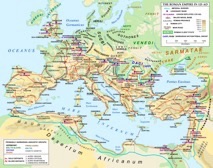
Rhaetia
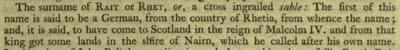
Alexander Nisbet, the most quoted source, in his System of Heraldry Vol 1 (1818) wrote that the name Rait is said to descended from a German of the district of Rhaetia (whence called Rait or Rhat), who, in the reign of Malcolm IV (1153-1165), came to Scotland with Keith, predecessor to the Earl Marischal, and got some lands in the shire of Nairn, where he built a castle, and called it by his own name. He may have left his homeland for religious reasons. (Nisbet seemingly acquired his information from the Families of Scotland complied some fifty years earlier wherein the ancient family of Rait or Rhet is mentioned - see under Raitt Name at bottom).